Fixing mistakes

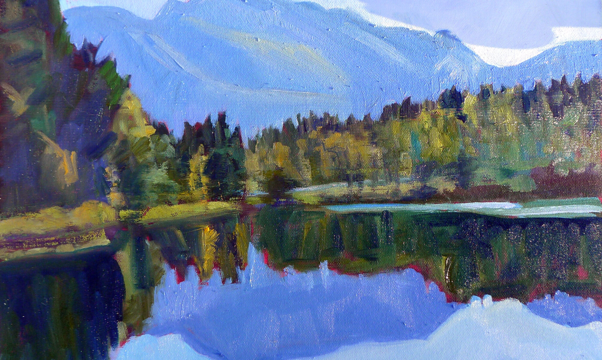
Mt. Hayes and the Alaska Range, by Carol L. Douglas
Sometimes when we rework old oil paintings, there’s a temptation to repaint the entire surface. The new paint looks lush and full; the old paint is dull and thin. That’s particularly true when you never got past thin layers in the first place. That old turpentine-thinned paint has oxidized. The drying leaves a pitted surface on the top of the paint, which appears chalky and grey.  
You can bring the color back up in these passages by varnishing, but you really shouldn’t paint into varnish or medium, no matter what you might have read elsewhere. The “fat over lean” rule applies even to old paintings.
If your painting is thoroughly dry, you can brush a light coating of turpentine or mineral spirits over the painting. That will bring up the colors of the oxidized passages long enough for you to make your corrections. It ought to stem the urge to repaint the whole thing. Of course, if large areas of your paintings are oxidizing, you’re not using medium correctly.
On Friday I shot an extremely short video of myself changing the color of the traps in a tree line. I sent this to a reader who was wondering how much paint to use in this correction phase. It doesn’t have much in the line of production values, but it might be helpful.
The painting of Mt. Hayes and the eastern Alaska Range was painted near Delta Junction, Alaska. It was early in our trans-Canada trip. Although it appeared surface dry when I wrapped it, the thicker white paint in the river and sky squished and flattened under the weight of subsequent paintings.
This was a simple resurfacing job—and that was a very good thing, since I have no reference photos. It also gave me the chance to adjust the color of the Tanana River, which looks like light chocolate milk, it’s carrying so much silt.
Lake of the Woods, by Carol L. Douglas
I’d realized after I left Lake of the Woods in western Ontario that I’d never actually finished painting in the sky. This was a very simple fix, but I used the moment to add a little warmth to the water in the foreground.
In the last painting, I corrected a lie. I’d intended to paint a house surrounded by fields and a windbreak, but couldn’t find the right combination of side road, farm and fields. In real life, my subject was fronted by a low waste area of reeds but I’d edited that out.
Windbreak, by Carol L. Douglas
When the glaciers from the last ice age receded, they left behind millions of shallow depressions. These wetlands are known as ‘prairie potholes.’ They are significant resources for plant and animal life and support millions of breeding waterfowl, whose numbers are being threatened as the potholes are drained for large-scale farming. I really shouldn’t have excised them from the one scene in which they appear, and it makes me consider whether I want to add a studio painting that does the potholes justice.
I expected that deleting the field and reinstating the reeds would take me a long time, but it was done in fifteen minutes or so. I will probably incise a little more texture into the reeds, but it’s never going to be my favorite painting.

Heart of the Continent

"Eastern Manitoba forest,"  by Carol L. Douglas

“Eastern Manitoba forest,” by Carol L. Douglas
As our tow truck brought us back into Brandon, an enormous fireball erupted to our right. “Oh, that’s just the airport,” the driver, Gerald Dedieu, said. It turns out that they do firefighting practice there in the off hours.
It was clear that we were going to kill some time in Brandon, so Gerald suggested we head down to his hometown of Souris in our loaner car. Souris has a creek, a suspension bridge, and a pretty setting, he promised us.
"Downtown,"  by Carol L. Douglas

“Downtown,” by Carol L. Douglas
The suspension bridge is Canada’s answer to the Jubilee Memorial Watering Trough. Every town apparently has one, Souris included. Instead of painting that, or Souris’ peacocks, I decided to paint a block of their downtown.
There is some debate about where the geographical center of America falls. It’s either in Rugby, ND, or just east of Winnipeg, MB. It hardly matters. Either way, virtually everyone on our continent is a southerner. Furthermore, most have not ventured north of the true Mason-Dixon Line, which is the 49th Parallel.
Minnesota owns a wee bit of land north of the 49th Parallel, due to a surveying error. The Northwest Angle, as it’s called, is cut off from the United States byLake of the Woods. To get there from the US, you need a boat, an ice bridge, or a passport, because the only roads come in from Manitoba. It’s got a population of 152 people and a land mass of about 600 square miles, of which 80% is water. This being a strictly Canadian visit, we did not detour there.
West Hawk Lake is surprisingly huge.

West Hawk Lake is surprisingly huge.
We did, however, visit West Hawk Lake. This is Manitoba’s deepest lake, at 115 meters. It was formed by a giant meteor, and its size is impressive.
West Hawk Lake is on Historic Route 1, so we ventured up that road looking for a glimpse of history. Alas, it was apparently recently bombed, so broken was the asphalt. We turned back.
"Lake of the Woods,"  by Carol L. Douglas

“Lake of the Woods,” by Carol L. Douglas
I set up to paint Lake of the Woods from the Discovery Center at Kenora. It was a great bonus, in my opinion, to have genuine running water and a soda machine at my disposal. Alas, there was a wedding being held there later in the day, so I was shooed along. I relocated a mile or so to the north.
I’ve switched mediums to Galkyd Light, since it’s all I could buy in Calgary. I’m having a hard time adjusting to it. It feels soupy. This is showing up particularly in my mark-making and in water reflections. I was struggling so much trying to find a workable scheme for the water at Lake of the Woods that I forgot to paint in the remainder of the sky.
"Thunder Bay,"  by Carol L. Douglas

“Thunder Bay,” by Carol L. Douglas
Western Ontario looks a lot like the Maine woods: granite and spruces and Jack Pines, and a whole lot of water. I was shocked, therefore, on arriving at Thunder Bay. Growing up listening to Canadian radio, I had always pictured it as a romantic place far west on the Great Lakes. Its waterfront is actually a lot like South Buffalo, which is where my people come from. The same neat workingman’s cottages march down to the same vast grain elevators.
The difference is that Thunder Bay’s grain elevators are still working. That’s because freighters take on grain here, rather than offload it. Today that grain goes right out the St. Lawrence into the world. Buffalo—the world’s first cross-docking station—is unnecessary.
Dusk falling on Lake Superior.

Dusk falling on Lake Superior.
I expected that one Great Lake shore was pretty much the same as another, but I was wrong. Here, red granite tops rough hills that drop to the lakeshore. This exposed granite is part of the vast Canadian Shield that forms the bedrock core of our continent.
As we drove east along the lakeshore, dusk dropped like rose-colored silk. A bear cub gamboled along the shoulder of the road. We were back in moose country. It was time to stop for the night.