Snowdrifts and shadows

A world without shadows is disconcerting; objects seem to float in space. Shadows give objects form and ground them.

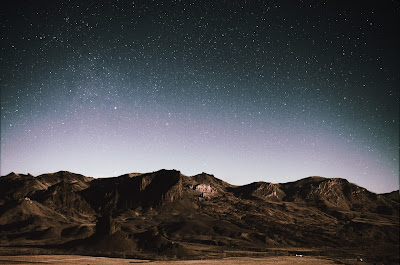
My son Dwight Perot took this photo of the Wyoming night sky last year at this time. It’s almost like this winter jaunt down US 90 is getting to be a habit.

It’s a balmy -2° F as I type this on Thursday afternoon in Blue Earth, Minnesota. These are temperatures we don’t typically encounter in the northeast, where our idea of deep cold is somewhat warmer. But it is, as they say, a dry cold. It’s miserable.

The Prius is ticking along quite beautifully, although we seem to have lost the front valance and lower grill somewhere in that snowstorm in Ohio. It was a typical winter storm, dumping about a foot of powder in Chicago, but it was preceded by a warm front which made wicked ice. That effectively encased the car, necessitating a quick windshield-wiper swap today. A few minutes without our gloves on, trying to manhandle the frozen clips loose, and our fingers were frozen.

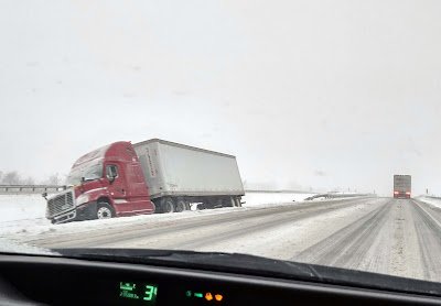
The trucks follow each other into the median like lemmings. I rapidly lost count of the wrecks along the Indiana Toll Road. It was just the same last year.

“There’s nothing to paint in the Midwest,” is a lament I sometimes hear, and one I adamantly disagree with. The sky is so spacious and the earth so flat that all spatial relationships are upended.

In the tropics, the summer solstice sun sits directly overhead at noon for just two days a year. The only American state that experiences this is Hawaii; the rest of us are too far north. A world without shadows is disconcerting; objects seem to float in space. Shadows give objects form and ground them.

Here in the north, the drifting snow drops down along the roadside, creating a curling ribbon of blue shadow that plays against the golden light of the sun. I’m not here to paint, but if I were, I’d stop and paint that.

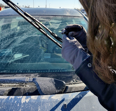
The ice storm shredded what was left of Dwight’s windshield wipers, necessitating a quick change.

There are solitary farms set within copses of trees, and power lines marching resolutely toward the horizon. A windsock is frozen in the last storm’s position.

The snow isn’t deep. Its surface is marbleized like sand dunes. That makes sense because they’re both sculpted by wind. But unrelated natural forms also mimic each other. The map of a river tributary system bears, for example, a striking resemblance to a tree. Why is that? Chance? Mathematics? Intelligent design?

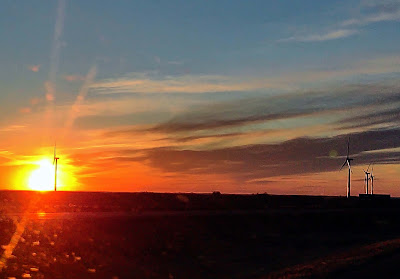
Windmills are part of the prairie landscape.

The grain elevators of Minnesota are mostly metal, unlike the frame elevators of the Canadian prairie just to our north. The prairie states and provinces developed with the same cultural, economic and environmental influences, so why did wooden elevators persist in Canada and not here? Are human beings that much more idiosyncratic than nature?

West of Illinois, rest stops become more austere. You no longer run a gauntlet of goods and services to reach the washrooms. But at the Missouri River in South Dakota, there’s a surprise: art and a small display about the Lewis and Clark Expedition.

At the Camp Pleasant rest stop above the Missouri River.

I-90 is the longest and coldest east-west road in the national interstate system. It was started in 1958 and not completed until 1978. It’s been part of my life for as long as I can remember, because the New York and Massachusetts sections are older than me. I know the section from Boston to Buffalo intimately, and that from Buffalo to Chicago quite well. I’ve driven the western section to Wyoming, but not often. The piece from Idaho to Washington is a mystery to me.

After yesterday’s storm, the sky is utterly clear. It would make for perfect night-sky photography, and both Dwight and I have cameras with us. However, we didn’t shoot any pictures. It was too miserably cold out there.

High Plains Pisseur

Coronavirus has closed McDonalds all over America. That’s tough on the long-distance driver.

Wind River Canyon, by Dwight Perot.

I thought I knew all there was to learn about the pipi sauvage, the business of peeing in open spaces. I’ve managed it on four continents. It’s less of an issue for men, whose clothing is designed for it. Women have to get creative about finding a place to crouch, but it can be done, even on the high plains without so much as a scrub pine in sight.

It’s not that Wyoming doesn’t have beautiful rest stops; they do. But once you leave the interstate, you leave the conveniences behind.  For both genders it’s gotten worse with the advent of COVID. McDonalds, that defender of long-distance drivers’ bladder health, has closed its lobbies in many states. It’s the tumbleweed or adult diapers in the age of Coronavirus.

The upthrust east of the Rockies, called High Plains, is beautiful, desolate and windy. Photo by Dwight Perot.

 The pipi problem was just the last in a line of small inconveniences. I never seem to be able to get on a plane and land three hours later, unruffled, at my destination. Perhaps that’s in part because I live 90 

minutes from the closest real airport, or that I prefer out-of-the-way end points.

Since I left Colorado in the early 80s, Stapleton Airport has been replaced by Denver International Airport. Like everything else on the Front Range, it’s bloated beyond function. It took way too long to cut loose with our bags and rental car. I was exhausted, but I soldiered on through dinner with family, and gratefully went to bed almost 24 hours after I’d risen.

Anticlines make for beautiful painting. Photo by Dwight Perot.

At 2 AM, I was awakened by a ringing doorbell. I peered out through the window slats and decided it was prudent to ignore. The doorbell rang again, this time accompanied by a maglight. It was a cop. He’d noticed a car door open; had we been burgled? The hoarfrost inside my rental car told the story; I’d just been too tired to close it. They say that exhausted drivers are as impaired as drunk ones, and that’s a warning I should heed.

The development that blights Colorado’s Front Range mercifully ends north of Fort Collins. I found a porta-potty in a city park in Cheyenne and struck northwest towards Cody. That route takes you east of the mountains, but the payoff is a fabulous climb through the Wind River Canyon, surely one of the great beauty spots in America. High plains drifting is not as dramatic as the mountain peaks of Colorado, but just as beautiful. My geologist son and I traced geological strata as we drove. Artists love anticlines because they produce wonderful angles; geologists love them for their oil deposits.

The beautiful Wind River. Photo by Dwight Perot.

We easterners must hydrate when we get to the Rockies. That unfortunately makes the pipi rustique problem an urgent one. North of Casper, I met my bête noire in the form of gale-force winds. Privacy wasn’t the issue; but peeing in a crouching position was darn near impossible. Men can just aim downwind; as for me, I’ll be doing laundry later today.

Approaching Cody. Photo by Dwight Perot.

I dumped the rental car in Cody and met up with Jane Chapin, who’d driven down from the ranch to collect us. There’s an amazing 360° mountain view from the ranch-house, and I can’t wait to paint. But first I must slap my plates on the truck I’ve driven out to collect, still scratched from the time we decided it was more prudent to back up through piñon than drive over a cliff. “That’ll buff out,” Jane had said. I’m still laughing about it two years later, and now it’s my truck, not hers. Yes!

Autumn color is hitching up its skirts and getting ready to sprint

Interested in fall foliage? This is the ultimate road trip for a leaf-looker.
Glade #1, by Carol L. Douglas. Watercolor on Yupo.

We haven’t had a frost yet, but with each day I see a bit more color. To date, it’s mostly the sumacs and undergrowth, but the top of the birches are starting to glint gold.

Someone sent me this cool interactive fall foliage map. It’s probably a good, broad sketch, but I’m skeptical about the details. I know, for example, that Penobscot Bay is unlikely to change in tandem with Fort Kent, ME. Nor will Rochester turn side-by-side with the high peaks of the Adirondacks.
Maine’s official color-spotters agree with me. “Northern Maine is at or near peak conditions the last week of September into the first week of October. Central, and western mountains of Maine are at or near peak Columbus Day week/weekend. Coastal and southern Maine generally reach peak or near peak conditions mid-to-last October.”
Glade #2, by Carol L. Douglas. Oil on canvas.
If it were up to me, I’d be heading north to Canada’s Algonquin Provincial Park today, with my canoe. It’s not a western park, but it would give me aspen, tamarack and maples, set against black spruce.
Then I’d spend a few days in Ottawa, Montreal and Quebec City for a dose of Canadian city life. I’d continue to Halifax and spend a few days knocking about Nova Scotia’s eastern shore, reveling in ancient maritime Canada. Eventually, I’d head to Digby and the ferry to St. John, NB. I’d then roll south, making sure to stop at West Quoddy Head Light and the boreal trail at Quoddy Head State Park.
Marshes along the Ottawa River, Plaisance, Quebec, by Carol L. Douglas
Stop right there, Carol. “You just skipped mysterious, moody Eastport,” I admonish myself. Well, I also skipped Lunenburgand Peggy’s Cove in Nova Scotia, and the fossil cliffs of New Brunswick. Not to mention the superlative Group of Sevencollection at the National Gallery in Ottawa. It’s impossible to list the interesting stuff you’d see on this trip, but if you can’t blow four weeks driving from Algonquin to Boston, you’re not really trying.
It’s under 3000 km. The trip of a lifetime, I tell you.
Speaking of the Group of Seven, I’m finishing up my residency at the the Joseph Fiore Art Center with a classically Go7 exercise which I periodically attempt and at which I never excel. That’s painting a glade. I don’t want a dominant tree, or to use white birches as a foil for dark foliage. I’m looking for a deeper kind of compositional integrity, and, so far, I haven’t found it.
This tiny glade first attracted me because of the glitter of the lone yellow tree against all that green. It would have been difficult enough to paint it in sunlight. In the dripping gloom and mist and rain we’ve had this week, it’s been maddening. I don’t think either painting was a success, but they’re both interesting, and that’s all I really want for today.
We’re winding down now. Clif Travers and I agree that today is the last day it’s possible to paint in oils and have work that’s dry enough to move. I may paint in watercolor Saturday, or I may coo at my brushes and clean up my kit for my next big event.

The Bourbon Trail

Our national identity is to be found in diners and city parks, cypress swamps and little towns, local church services, at Home Depot, on city streets and lonely country roads.

I may have the wrong footwear for Buffalo…
As much as I like overseas travel, I’ve never felt the urge to teach in another country. Landscape painting conveys a deeper shade of intimacy that I simply don’t feel when visiting other places. I enjoy them, but I don’t love them in the same way as I love the US and Canada.
I took this trip to pave the way for a workshop in the Deep South. Why didn’t I just head to the more familiar eastern seaboard states? I’m familiar enough with them that a road trip wasn’t necessary. The central south has been calling to me for a long time, although I’m still not sure what it’s saying.
I usually approach Kentucky from the north. It seems very southern compared to Ohio. This time, driving up from Mississippi, it seemed northern, its drawl flattened out to a midwestern twang. Either way, its identity is confused. This is where the great antislavery novel, Uncle Tom’s Cabin, was set. When Eliza struggled across the frozen Ohio River, she was literally leaping from slavery to freedom.
One-lane road, central Kentucky.
And yet, nowhere was ‘brother against brother’ truer than in Kentucky. The state tried to sit out the Civil war, but its self-declared neutrality was ignored by both sides. Eventually, it cast its lot with the Union. But southern sympathies were strong, and a group of citizens formed a shadow government that joined the Confederacy.
I came to love Kentucky when I did art festival in Louisville. Now I take every opportunity to shun-pike through this state. It has beautiful farms, lovely steep hollows and hills, and the biggest known cave system in the world. But I was being a serious driver yesterday, intending to get from Bowling Green to Buffalo, NY in one shot. That meant sticking to the Interstate system like a burr on a saddle-blanket.
Dogwood and distillery.
Maybe it was the knowledge that there was snow ahead, but I couldn’t resist veering down the Bluegrass Parkway. This runs east to Kentucky horse country. These are the most manicured farms in America, and the horses—even the ones free to graze near the road—are beasts of singular beauty. The spring grass is in, and the horses were gamboling in the sun.
Before I got that far, I saw a sign for Kentucky’s Bourbon Trail. That eventually put me on a series of one-lane roads. The blind corners, cropped hedges and small-town distilleries reminded me of the Isle of Skye.
Most of us, when we say we’ve ‘been to’ a place, mean we’ve driven through on the Interstate or we’ve flown in, gone downtown, eaten at trendy restaurants and seen a few tourist sites. You really don’t learn much about your country like that. Our common ground is to be found on the old Federal routes, at diners and city parks, in cypress swamps and little towns, at local church services, or talking to the guy at Home Depot. We should all do more of that.

Île d’Orléans autumn day

“Île d'Orléans waterfront farm,” by Carol L. Douglas.

“Île d’Orléans waterfront farm,” by Carol L. Douglas.
Gabriel-from-Quebec tipped us off that Île d’Orléans, just a few minutes downriver from Quebec City, would be a great place to paint. Electronic media puts you in contact with people you would never have met otherwise. They’re frequently excellent sources of information.
The Île was settled in the 17th century and evidence of its feudal system is still visible. Small holdings stretch in narrow strips down to the water. This put tenants close to their neighbors and maximized access to the water.
Quebec City is also a city of waterfalls. Montmorency Falls is 272' tall, making it nearly a hundred feet taller than Niagara Falls. And it has the requisite suspension bridge, too.

Quebec City is also a city of waterfalls. Montmorency Falls is 272′ tall, making it nearly a hundred feet taller than Niagara Falls. And it has the requisite suspension bridge, too.
It’s hard to imagine that a feudal system was ever successful in the New World, let alone that it persisted for centuries, but that happened in French Canada. Seigneuries were not granted to nobles as in France, nor did the land grants confer nobility. They were generally given to military officers and churchmen for services rendered. Later, these seigneuries were purchased by canny English and Scottish investors who recognized a profit when they saw it.
The tenants cleared the land, built their own homes and barns, farmed, and paid rent to the seigneur. They were suckers to the Crown, since in New France, land was plentiful and labor was dear. Still, the system was not formally abolished until 1854, long after the demise of New France. The last rents were not settled until—seriously—1970.
Île d’Orléans is too varied to ever be captured in one painting. In some places it is Quebec agriculture, with strawberry fields and apple orchards marching neatly down to the St. Lawrence River. In others, it looks surprisingly like the Maine coast, with seasonal cottages set among woodland. Houses of mellow golden stone dot the landscape.
While I painted, Mary quizzed me on French animal names. Vaches and poulet I already knew; dauphin confused me. Wasn’t that the title for the heir apparent to the French crown? Souris amused me, because I’d just painted in a Manitoba town of that name last week, and it was, indeed, just a little bit mousy. It was a beautiful, warm, autumn day. Abeilles buzzed among the the clover.
"Bas-Saint-Laurent sunset," by Carol L. Douglas.

“Bas-Saint-Laurent sunset,” by Carol L. Douglas.
I hated to leave Quebec without another painting, even if our detour to Île d’Orléans had been time-consuming. At La Pocatière, I stopped to paint the sun setting over the St. Lawrence estuary. Even this far upriver, the St. Lawrence is vast enough that there are beluga whale nurseries. At the moment, there were also two men parasail-waterskiing in the stiff wind.
The paper mills at Edmunston, New Brunswick and Madawaska, Maine call to me even in the dark.

The paper mills at Edmunston, New Brunswick and Madawaska, Maine call to me even in the dark.
The Bas-Saint-Laurent is a beautiful area and so is the St. John River Valley, where we stopped for the night. This is home country. In fact, a right turn and we could be home for lunch. In many ways, that knowledge is the hardest thing we’ve encountered so far.

On the edge of civilization

"McDonald Creek," by Carol L. Douglas

“McDonald Creek,” by Carol L. Douglas
I’ve seen Mary’s headache, malaise, and swollen neck before. Her older sister had mononucleosis in college and looked and acted the same way. When Mary’s tonsils started to swell, I decided to make quick time to a medical clinic at Ft. Nelson, BC.
Three minutes and $70 later, Mary exited with a scrip for penicillin. No blood tests, no swabs; the doctor took a quick look in her mouth and announced it was tonsillitis. Penicillin won’t hurt the girl and might actually help, so we had it filled. Mono is untreatable anyway.
Mary took a nap in the sun while I painted.

Mary took a nap in the sun while I painted.
My husband asked why I didn’t see the doctor myself, since I’m still hacking. I just have a cold, I answered. For less than the cost of penicillin, I can rinse my mouth with Alberta rye whiskey. If it doesn’t cure me, at least I won’t mind so much.
Fort Nelson is on the east slope of the Rockies. It seems positively cosmopolitan compared to where we’ve been. Some women have tri-colored highlights in their hair, all in the same gingery tones. That, I presume, implies a beautician in town. There is clothing other than camouflage, although the Super 8 where we’re staying does have a sign asking visitors to remove their muddy boots.
Trail riders are a common site in northern British Columbia.

Trail riders are a common site in northern British Columbia.
Hayfields and buildings appear sporadically along the road into town. The tree cover looks more familiar to my eastern eyes. Mixed forests of predominantly deciduous trees cover the lower slopes.
Today we will follow the Alaska Highway to its starting point at Dawson Creek. This will take us down into the prairie land of Peace River Country. This area was explored during Sir Alexander MacKenzie’s journeys of 1789 and 1792-3. The latter was the first east-west crossing of North America north of Mexico, preceding the Lewis and Clark expedition by 10 years.
Like so many great American explorers, MacKenzie’s goal was to find a water route across the continent—the fabled Northwest Passage that beguiled the Vikings, Cortés, Sir Francis Drake, John Cabot, Henry Hudson, LaSalle, and so many others. MacKenzie, however, managed to reach all three great oceans that surround Canada, and his explorations took him on the longest possible route, for the continent grows wider as it goes north.
My main companions yesterday were bears, not hoofed things. It's almost time to hibernate.

My main companions yesterday were bears, not hoofed things. It’s almost time to hibernate.
Our prairie time will be briefly interrupted with a slight detour into Banff and Jasper National Parks this weekend. After that, I’m hoping to make better time. A flatter road will be nicer on the old hooptie, which seems to have sprung another exhaust leak. Poor old thing. I’m not sure who’s suffering more, the car or Mary. I’ll push the liquids at both of them.

Another Roadside Attraction

Sketch of a commercial building somewhere in Binghamton, NY, done from a diner window. Sadly, I could never find it again, and they had really good pie.

Yesterday I was flipping through a used-up sketchbook, and came across this little watercolor done many years ago. It’s another roadside scene en route to New York City; however, this one wasn’t memorized across the steering wheel.
I spent several years driving back and forth to the Art Students League from Rochester. I had a little bolt-hole near the Cathedral of St. John the Divine and a Ford Windstar wagon. (Gas was cheaper then.) I drove that route through snowstorms, ice, and flooding , which in the Susquehanna River watershed is the most terrifying of driving conditions. When I was too bleary to drive, I would pull off in a rest stop and sleep in the back of my van.
One early Spring evening, the Windstar died with a colossal bang in that no-man’s-land between Binghamton, NY and Scranton, PA. The tow-truck driver set me down at a diner where I sat with my sketchbook and pondered the situation. All’s well that ends well: I got a cheap hotel room, sold the carcass to the tow-truck operator for $600, and went to New Jersey to test drive one of them new-fangled Priuses.

The trip to Maine is more interesting driving than the Rochester-Manhattan loop. If you’re interested in joining us for a fantastic time in mid-Coast Maine this summer, check here for more information. There’s still room in my workshops.